Feeds:
Posts
Comments

Archive for the ‘Outdoor Activities’ Category

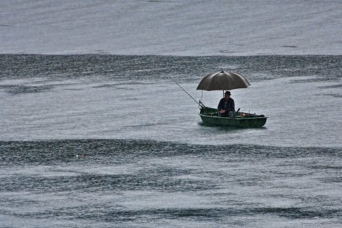
Fishing_in_the_Rain_by_AndrewPoison

By J Motes

Fishing in the rain is something that most people do not look forward to doing. Hank Williams Jr. summed it up pretty well when he sang, “…and I’m against fishing in the rain.” Fishing in the rain can be a miserable experience for the fisherman or fisherwoman, but unless it is a complete downpour or there is flooding, fishing in the rain usually beats most other times to fish.

One reason that fishing in the rain is so productive is that the rain drops break up the smooth surface of the water and thus reduces the penetration of light into the water. Fish that shy away from bright light will come out to feed. Also rain will wash insects and other food sources into the water. While small tributaries are always great places to fish, these areas are often more productive with the rain bringing even more food into the water.

To be out fishing in the rain for long and to not be comfortable, the fisherman needs to dress for the weather. In many places a fisherman can find a location to fish under a roof, a canopy of trees, or other shelter. If this is not possible a wide brimmed waterproof hat will suffice. Comfortable fishing also requires a dry seat. Those fishing from boats should bring along a piece of plastic or something similar to cover up your seat and a towel to dry it off. Those fishing from shore need to bring a hunter’s seat strapped to their belt to keep their hind end dry both while walking and sitting. A folding stool may work as well. If you are going to be sitting in the open while fishing in the rain, a large golf umbrella might be a big help. Waterproof shoes or boots are a must also to keep your feet dry. However, if it is quite warm, shoes that drain well will work well also. If you are going to wade in the rain I suggest wet wading (without waders). If you must wear the waders in the rain, a light jacket will help to keep rain from running into the waders, which can be quite annoying.

As far as the actually fishing, little changes in the rain. While a steady rain might make it difficult for fish to see top water flies and other lures, nothing else will change significantly from my experience. Do keep an eye out on changes in the water as rain will often cloudy the water and necessitate lure color changes.

Safety is another concern. Be aware of flash flooding when fishing in the rain. While the rain may be relatively gentle where you are, areas upstream may be getting a severe down pour. Lightning is another concern. No fish is worth getting struck by lightning, so stay off and away from the water when there is lightning. Footing will of course be more slippery in the rain, so watch your step.

While fishing in the rain can be frustrating and uncomfortable physically, the fishing itself is often quite good. One more reason to fish in the rain? You are often the only one there!
Read Full Post »

Moosehead Lake in Autumn

NEW YORK, March 30, 2012 – About.com today announced that Greenville, Maine, has been selected as the 2012 About.com Readers’ Choice Award winner for Best New England Fall Foliage. Now in its fifth year, the About.com Readers’ Choice Award honor the best products, features and services across more than a dozen categories, ranging from technology to hobbies to parenting and more, as selected by its readers.

“This year’s Reader’s Choice Awards program had a record number of nominations submitted across dozens of categories and featured hundreds of finalists,” said Margot Weiss, managing editor, About.com. “We are thankful to all our readers for their participation and congratulate Greenville on its success.”

FMI: On the Moosehead Lake Region please visit the Moosehead Lake Region Chamber of Commerce Website at:

http://www.mooseheadlake.org/

Read Full Post »

Campers span a broad range of age, ability, and ruggedness, and campsites are designed in many ways as well. Many campgrounds have sites with facilities such as fire rings, barbeque rings, utilities, shared bathrooms and laundry, as well as access to nearby recreational facilities, but not all campsites have similar levels of development. Campsites can range from a patch of dirt, to a level, paved pad with sewer and electricity.

Today’s campers have a range of comforts available to them, whether their shelter is a tent or a recreational vehicle. Those choosing to camp closer to their car (“car camping”) with a tent may have access to portable hot water, tent interior lighting and fans, and other technological changes to camping gear. For those camping in recreational vehicles (RVs), options may include air conditioning, bathrooms, kitchens, showers, and home theater systems.

Tent camping sites often cost less than campsites with full amenities, and most allow direct access by car. Some “walk-in” sites lie a short walk away from the nearest road, but do not require full backpacking equipment. Those who seek a rugged experience in the outdoors prefer to camp with only tents, or with no shelter at all (“under the stars”).

Indian Hill Trading Post is equipped with anything you might need for your next camping trip. Stop by today and see our large selection. We have new items arriving daily.

Read Full Post »

Upper Falls of Little Wilson

Little Wilson Stream’s upper falls is a scenic landmark in Maine’s ‘100-Mile Wilderness’ (the most remote section of the Appalachian Trail). It is in Elliotsville Plantation, six miles northwest of Monson, off Elliotsville Road.

To get there from Monson, drive to the Elliotsville Road bridge that crosses Big Wilson Stream, turn left on a logging road immediately before the bridge. Drive about a mile north (along Big Wilson Steam’s east bank) to a clearing (and old campground) at Lower Little Wilson Falls. The lower falls has a beautiful flume and a deep swimming hole with a rope swing. These are worth visiting by themselves, but if you’re up for a half-hour hike, the upper falls is well worth the effort.

Follow the footpath on the south bank of Little Wilson Stream, which starts at the lower falls. This path is a spur to the Appalachian Trail, and you’ll join up with the AT three-quarters of the way to the upper falls.

The upper falls has a drop of about 60-80 feet. It rivals Moxie Falls (near the Forks) in height. Its most interesting feature is the moss-covered slate on the north wall of the gorge. Very primordial!

The upper falls is very difficult to photograph, unless you ford the stream above the falls and bushwhack to spot on the north rim. The south rim has the most accessible view, but you can’t capture the whole drop even with a good wide lens. The photo is of only the tippy-top of the falls, from the south rim.

The falls are geolocated here:

http://picasaweb.google.com/w.eric.schult/ScenesFromMaineS100MileWilderness#5286404263635290002

Other photos here:

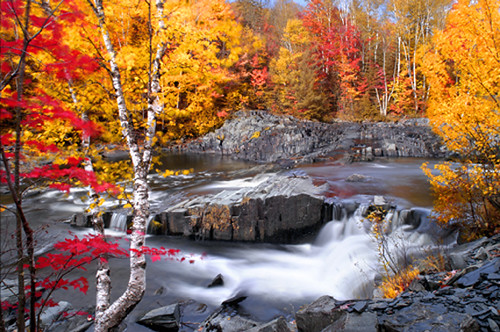
Autumn Stream

Read Full Post »

Read Full Post »

Read Full Post »

Photo of a logbook inside a cache

Would you like to add an element of surprise and discovery to your travels? Go geocaching!  Geocaching is a treasure-hunting activity with a high-tech twist. All that’s needed is a handheld GPS unit and a sense of adventure.

How does geocaching work? It’s quite simple. A cache is hidden by a geocacher and its GPS coordinates are posted at www.geocaching.com. Fellow geocachers look up the coordinates and try to find the cache.

What is a cache? A cashe can be just about any size, but the container needs to be weatherproof and watertight. Inside the cache is a logbook where geocachers record when they find it. Depending on the size of the cache, it may also contain small items for trade such as souvenir trinkets, small toys, keychains and buttons. If you take an item out, you put another item in – that’s trade etiquette.

Sound like fun? Give it a try, I bet you’ll be hooked!

Read Full Post »

Read Full Post »

Moosehead Lake is New England’s largest body of water, spanning an incredible 117 square miles. Lily Bay State Park encompasses 925 acres along the southern edge of the large bay, which is dotted with dozens of islands thick with fragrant spruce and fir trees. The sandy beach at Dunn Point makes for great swimming and offers beautiful views of Sugar Island and the big lake beyond. There are two nearby parking areas, a boat launch, restrooms, picnic tables and grills, potable water and a playground. Rowell Cove also sports a boat launch and parking.

Canoeing and kayaking the placid waters of the bay and motor-boating out on the lake are fun ways to spend the day. The lake is prized for its fisheries of brook trout, lake trout and landlocked salmon. With plentiful moose, deer and bear in the area, wildlife watching is good sport. A two-mile hiking trail connects the beach at Dunn Point to Rowell Cove and is great way to explore the wooded park.

The park hosts two campgrounds in close proximity to each other, one at Dunn Point and another just to the east at Rowell Cove. There are total of 90 campsites for tenting, camper trailers and RVs; 22 are walk-in tent sites. Many of the campsites are just short distance from the lake. Restrooms and water faucets are conveniently located throughout the campgrounds. Hot showers are located near Dunn Point.

Stop by Indian Hill Trading Post on your way into town…we have everything you need for your camping experience…


Read Full Post »


This is a very beautiful hike. You will pass three very picturesque mountain ponds in a distance of only four miles.

Directions from Greenville: Travel approximately 5.3 miles north on Route 15. Take a left on the dirt road directly across from the Forest Fire Danger level sign. (Just past the Maine Forest Service Squaw Brook Campground.) Travel a little less than a mile on this road. Look carefully for a sign on the right, which marks the trailhead. Follow the road beyond the Big Squaw trail head to the Y to the gravel pit. You will see the post headings of the trail approximately 1/2 mile from the gravel pit. Follow the trail to the edge of Little Squaw pond. Papoose Pond will be on your left. After Papoose Pond, you may follow the trail to the left which ends behind the Moose Mountain Inn or you may follow the trail to the right which will take you around Little Squaw Pond. If you continue to bear right, you will come back down between the two Squaw Ponds. At the top of the right hand turn, if you turn around, you will note a spectacular view of the south and the east. (This portion of the trail is the most difficult and should be approached only from the south to the north, unless you are a seasoned hikers. From north to south it is a very steep, uphill climb.). If you choose to follow the trail straight ahead, you will have a relatively easy hike to Little Notch Pond (approx. 25 minutes)This trail ends just beyond the pond, therefore you will have to turn around and return to the downhill trail on the left, between the Squaw Ponds to return to your starting point.

Time: This entire trip will take you between 3-½ and 4 hours depending upon your hiking speed and ability.

Read Full Post »